


What is Evapotranspiration (ET)? is the process of transferring water from soil and plants into the atmosphere.
- Think of Evapotranspiration (ET) as Evaporation (when water vapor leaves the soil or a plant’s surface) plus Transpiration (the passage of water through a system (plant, soil, body) to the atmosphere).
What is ET used for? ET values provide accurate calculations of the amount of water needed for specific weather and sets of plants. It is expressed in inches of water needed to replace that lost to the atmosphere in a given time period. WT Controllers use ET to determine water requirements, eliminating waste and offering direct savings on water and indirect savings on plant costs and hardscape expenses.
Why Adopt an Irrigation System Based on ET? If we can accurately determine how much water has entered and left plants and surrounding soil, we can determine how much water a landscape needs at any point in time. HydroPoint, the long-time leader in smart water management, uses ET values to determine the right amount of water for a specific landscape environment. We’re the only water management solution to use the four-parameter, international calculation standard, Penman-Monteith. The HydroPoint Advantage:
- Unparalleled accuracy. HydroPoint ET calculations have been independently proven to be within 2% of an actual on-site weather station.
- Precision results to each specific location. The results are precise to within one square kilometer, ensuring you’re not watering your landscape based on a remote or sensor limited weather station.
- Timely. HydroPoint transmits daily ET data to control irrigation at each individual controller.
-
Prevent Overwatering. Optimizing water usage for landscape irrigation means you won’t have to replace your plant material or hardscape (retaining walls, wooden fences, masonry, etc.) as often. When plants look unhealthy, the common reaction is to turn on the spigot. In reality, most landscapes surrounding buildings, parks, and schools are overwatered. Overwatering has several consequences:
- it is the cause of the vast majority of issues experienced by plants and trees, particularly disease.
- it can cause soil consolidation, a leading cause of concrete slab foundation problems and failures, reducing the life span of your asphalt and paved surfaces.
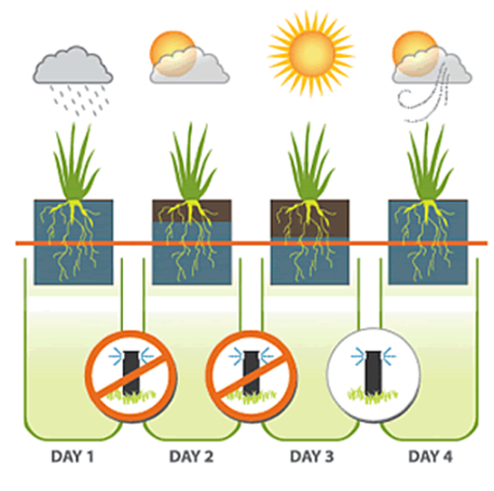
- cause runoff, which are prevented in irrigation systems with automated cycle and soak capabilities as soil has an opportunity to absorb the water.
- Reliable. By using redundant calculations and relying on numerous data points and weather stations, there is no single point of failure. HydroPoint irrigation systems do not rely on external or add-on devices that could fail, such as weather receivers, soil moisture probes and temperature sensors.
- Centralized control. ET values and local site conditions provided by HydroPoint’s climate center drive irrigation scheduling engines. You get automated, centralized control that can be used from a desktop or on-the-go from a mobile device.
- Easy to deploy and maintenance free. HydroPoint solutions are simple to deploy and require no end-user calibration, keeping your overall cost of ownership low.
How is an ET calculated? ET is calculated using four factors; temperature, humidity, wind and solar radiation. These are entered in an equation from which we are able to derive the associated ET number.
Calculating ET
There are numerous factors that impact the rate of evapotranspiration, including temperature, location, soil type, wind, solar radiation, and humidity. Every location or site has different water needs every day. There are numerous ways to calculate ET to determine watering needs. Irrigation Solutions need to use weather to determine microclimates and sets watering schedules, but many methods do not yield good results.
Example problematic methods include property owners and managers that purchase their own mini weather stations, but these tend to require frequent calibration and maintenance and are notoriously unreliable. The easiest way involves averaging ET values from the two nearest weather stations, but microclimates even a few kilometers apart can produce substantially different values. Using remote weather stations or weather stations with limited sensors or zip codes also result in misleading data. A relatively simple ET calculation method called Blaney-Criddle is popular but tends to be inaccurate in areas with higher humidity. The Makkink method requires weather station calibration for each specific location. Another frequently used method, called Hargreaves, uses a single sensor. Results can be up to 60% different than other methods, calling their outcomes into serious question.
In an effort to determine the most accurate way to calculate ET and standardize on a single method, the Irrigation Association commissioned an independent study from the American Society of Civil Engineers (ASCE). After extensive research, it was determined that the ASCE Standardized Penman-Monteith was the winner. Unfortunately, calculations using Penman-Monteith are problematic because it takes so many factors into account.
HydroPoint ET Calculation
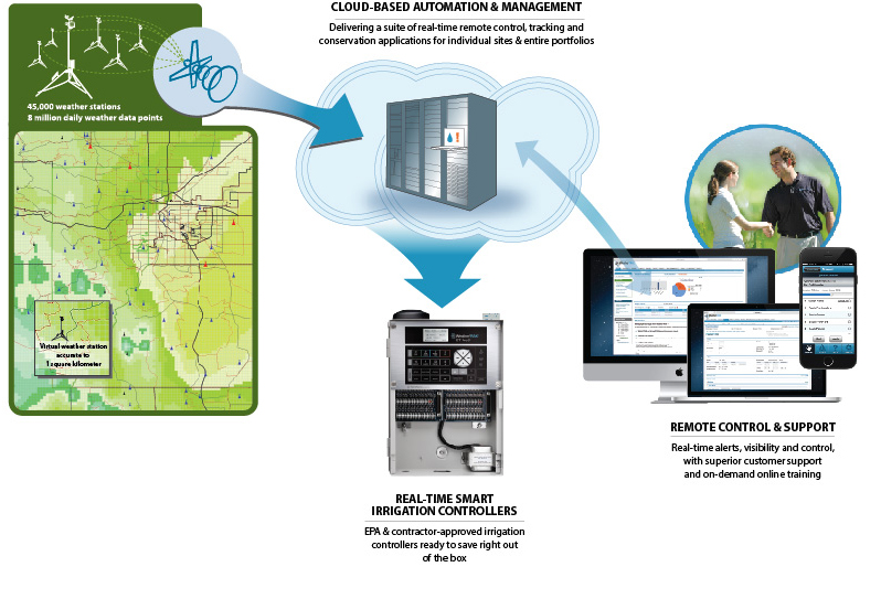
Valuing accuracy and precision, HydroPoint set out to incorporate Penman-Monteith calculations into its proprietary weather model. With nearly 8 million one-square-kilometer grids across the continental U.S., however, modeling the equation with four input parameters is exceedingly complicated.
To manage the complexity, HydroPoint uses highly sophisticated software running on a high-performance computing cluster in HydroPoint’s climate center. Every day the climate center downloads:
- 8 million real-time data points via satellite and internet from the National Oceanic and Atmospheric Administration (NOAA) and local mesonets
- Surface observations collected hourly from ground weather stations, ocean buoys, and weather balloons around the world
- Global satellite-imaging data every 15 minutes
- Hourly Doppler radar data for the U.S.
In addition, the model uses 256 categories of local ground information such as topography, soil, vegetation and land use. Redundant calculations are made, and the resulting data is inserted into databases using proprietary code.
Ground weather readings can be wrong. So, just how accurate is the data? To ensure accuracy, HydroPoint wrote a heuristic algorithm that crawls through the incoming data day in and day out, weeding out anomalous readings. Data is disqualified, for instance, if there are big swings in temperature or humidity readings from one hour to the next at the same weather station.
To translate ET values into an irrigation schedule usable by a controller, HydroPoint developed scheduling software that factors in ET plus easy-to-enter zone specific parameters entered by someone familiar with the site – from plant and soil type to sprinkler-head model. In addition, HydroPoint analyzes Doppler radar data, essentially creating an on-off rain switch. The moisture depletion rate is calculated by subtracting the estimated daily ET loss for each square on the grid, thus determining how long the irrigation pause should last—information that is sent to HydroPoint controllers.
The result is both historical and real-time site-specific weather and accurate ET values to drive irrigation for any location, down to a square kilometer, without the need for weather stations or sensors on-site.
Data Related Questions
What is Hydropoint’s ETE Data Service? HydroPoint’s ETE Data Service is a Secure FTP accessible service that allows subscribers to retrieve the ET value for specified locations with resolution of one square kilometer, for the specified time period.
What information do I need to provide? Once subscribed to HydroPoint’s ETE Data Services via FTP, you simply work with HPDS technical staff to develop a text file in the required format containing a list of the microzone coordinates for which you require ET values, and they will be calculated daily and made accessible for you to download in CSV text format.
How do I access HydroPoint’s ETE Data Service? We’ve made access to the ETE Data Service easy and secure by utilizing the Secure File Transfer Protocol (FTP). Simply open an SFTP session to our server at ftp.wtdata.com, enter your provided login credentials, and the last 45 days of data for your submitted coordinates is available for download.
What is the data output format? Your ET data will be downloadable in a text file, in comma separated (CSV) format. Each line of the file will contain the following data for each coordinate you submitted, terminated with CRLF.
- For customers submitting lat/long coordinates: Latitude, Longitude, Start Date, End Date, Microzone, ErrCode, ErrText, CustomerRef, ET
- For customers submitting microzone coordinates: Microzone,Start Date,End Date, ErrCode, ErrText, ET
What is the filename convention? YYYYMMDDET.csv
How often are new ETE data files generated? Hydropoint’s ETE Data Service generates your data daily.
What time are new ETE data files available? Your data will be prepared and ready for access by 3 PM PST daily.
Support Related Questions
How do I change my account information? Contact your assigned HydroPoint Sales representative.
Who do I contact for technical support or service issues? Simply call HydroPoint at 800.362.8774 and ask to be connected to the IT Services team.
Who do I contact for data questions or issues? For questions about your data, contact Hydropoint’s IT Services team.
Other FAQ
Why is ET Important? Water continuously moves between the oceans, sky, and land. This ongoing circulation is fundamental to the availability of water on the planet and, therefore to life on earth. ET is a key process within this cycle and is responsible for 15% of the atmosphere’s water vapor. Without it, clouds couldn’t form, and rain wouldn’t fall.
What is SFTP? SFTP stands for Secure File Transfer Protocol. It is a standard method of transferring files securely over the Internet. For more information on using SFTP, or automating file retrieval with SFTP, see your SFTP client documentation.
Where can I get an SFTP client? Reliable and easy to use SFTP clients are available in several open source implementations, for Unix and Windows operating systems. An internet search will reveal several alternatives you can select from.